|
|
Photo of the Week
April 30. 2006
|
|
|
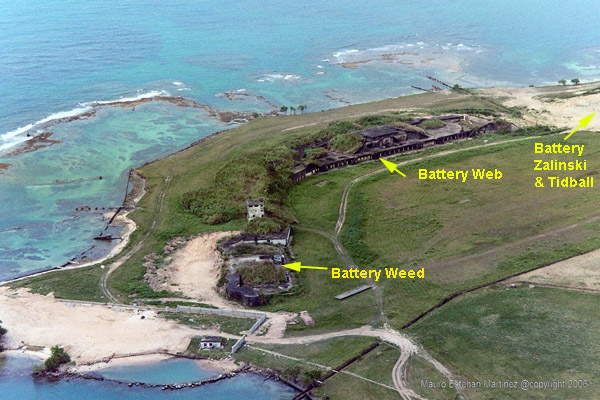
CZ Images contributor Mauro
Martinez sent me this super aerial photo taken of the old Fort Randolph
area. It appears that the area is slatted for development into a resort
of some kind. What you see here in this photo is the last image of a
very historical defense site for the Panama Canal. This photo only shows
half of the Fort Randolph base. It appears that parts of it on the far
upper right of the photo have already gone under ground breaking. I am providing a really great site
plan map of Fort Randolph to give you an idea of what it consisted of during
the coastal defense days. (Click
here to see the .pdf image map). The narration
below and .pdf map are from Charles S. Small's book Military Railroads on
the Panama Canal Zone. FORT RANDOLPH Margarita Island was roughly 1/2 a mile wide and about as long. It was surrounded
by a coral reef. The track layout was very simple. It consisted of an incomplete
loop although probably while the initial construction was in progress the loop was
closed. The line which branched off near the entrance served the storehouses. There is no record of locomotives being stationed at Fort Randolph. Service both
during construction and later when the garrison was in place was provided by the
Panama Rail Road. There was one siding for a rail mounted searchlight No. 4 and
access was gained by a switch back arrangement. Other searchlights were installed on islands to the east. The trestle was rebuilt. Rock was only plowed off the 5290 feet of the outer end. The line from the shore to the beginning of the breakwater was 5693 feet long. The breakwater was completed mid-1016 after 4,000,000 odd tons of rock had crossed the Isthmus and traveled over the Margarita Point Railroad. |
Home|
Photo
of the Week | Photo
Archives | Main
Show Room | Photo
Room | Military
History
PC
History | Sign
Guest Book | Read
Guest Book | Search
CZ Images | CZ
Web Searcher
Gift
Shop | Book
Store | Links