|
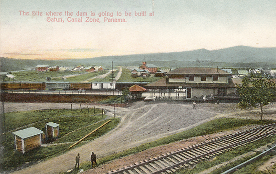
This
photo shows the old town of Gatun as it was situated on the bank of the
Chagres River. The train station is modeled after most others
along the Panama Railroad at this time. (See
PRR Stations). The town
can be seen in two sections divided by what looks like a road. By
looking to the right of the church, and behind the railroad station, you
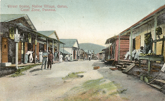
can see the other section. The part of town on the left could be
what they referred to as the "Native Village" which was
inhabited mostly by West Indians and European laborers. The Chagres
River can be seen in the distance.
Here
is a great little historical description that I copied out of "The
Panama Guide" by John O. Collins. It is an article out of
an issue of the Canal Record.
Gatun was not always a brand-new village perched on a hill overlooking
the valley. Says The Canal Record:
The old village of Gatun, which
lay on the river flats below the present town was abandoned in 1908, and
the site is now covered by 80 feet of rock and earth under Gatun Dam. At
the time it was abandoned, the village contained a church, priest's
house, school, a dozen
small shops, and ninety or more small houses of all descriptions, from
the bamboo hut with palm thatch to the typical sheet iron roof shanty.
Most of the buildings were moved to the new townsite known as New Gatun.
The railroad line also ran though the dam site and as soon as the
present line into Gatun was opened, this likewise was abandoned, and the
station building was razed. By the middle of 1909 the last vestiges of
the old village had disappeared before the encroaching work on the dam.
The antiquity of the place is uncertain,
because none of the its buildings were of masonry. In his narrative of
the pirate Morgan's march to Panama in August, 1670, Esquemeling says:
“The first day they sailed only six leagues, and came to a place
called De Los Bracos. Here
a party of his men went ashore, only to sleep and stretch their limbs,
being almost crippled with lying to
much crowded in the boats. Having
rested awhile, they went abroad to seek victuals in the neighboring
plantations; but they could find none, the Spaniards being fled, and
carrying with them all they had.”
The
location on the river corresponds to that of Gatun, for six Spanish
leagues equal about nine miles, and even if the situation of
De Los Bracos is not identical with
old Gatun the narrative indicates that the region thereabouts was
somewhat settled. It is known that the Spaniards had erected a fort on a
hill 120 feet above the river, overlooking the town, which was probably
one of the outposts they had established at various points along the
isthmian trade routes. Evidences of the old fort are found today, and
the site is shown on the original land-map made for the Panama Railroad
in 1855. At that time the
village had about one hundred buildings of all kinds.
Writing of it in 1861 Otis says it was a village composed of
forty or fifty huts of cane and palm. In the early days of the
California immigration it was the first stopping place in the canoe
journey up the Chagres where "bongo-loads of California travelers
used to stop for refreshments on their way up the river, and where eggs
sold four for a dollar, and the rent for a hammock was two dollars a
night.”
In
1881 the French chose Gatun as the site for one o the canal residencies,
erected machine shops there, and built a number of quarters for
laborers, calling the new section, "Cite de Lesseps.” This
continued as a center of the work of excavation until 1888, when all
operations ceased, not to be resumed here until 1904.
When
the Americans arrived in 1904, Gatun was the center of a comparatively
large river trade. Bananas and other produce from the Gatun, Trinidad,
and Chagres Rivers, were brought there for transshipment by rail, and
for sale. Once a week,
a shipment of from seven to nine carloads of. bananas was made, and on
the shipping day, as many as a hundred canoes would up at Gatun.
See
map
|